Absocachinlutely! Rotating Header Image

Maps

Ohio Delorme Challenge

The Ohio Delorme geocache requires a visit to each cache in the Delorme atlas for Ohio but only visits after the cache was placed will count towards the cache find. Once a cache has been found on each page you then get the co-ordinates for the final cache hidden somewhere in Ohio.

With the aid of a KML file, the recent finds pocket query, GSAK and Google earth it is quite easy to work out which pages you need to do.

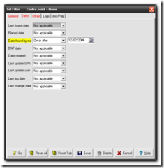
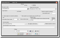
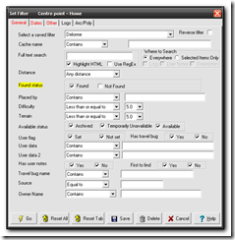
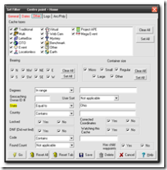
First download the Ohio Delorme KML file from the main cache page, GCZ554. Next download Google Earth (if you don’t already have it already. Finally  you want a .loc file of all your finds since the 2nd of December 2006 when the cache was placed.  The easiest way to do this is to download your latest finds into GSAK, then using the filters set State=Ohio, Found=Yes, Date=On or After 12/2/2006.  I saved the filter as Delorme so I can run this whenever I need to check my status.

Screenshot - 7_21_2007 , 5_31_23 PM Screenshot - 7_21_2007 , 5_31_12 PM Screenshot - 7_21_2007 , 5_31_16 PMScreenshot - 7_21_2007 , 5_31_47 PM   

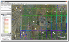
In Google earth open the KML file and then open the loc file  to see the caches appear in gridlines for each page. You may want to turn off extra options and layers such as road names, community uploaded content etc. This will give you a cleaner picture. Screenshot - 7_21_2007 , 5_32_03 PM
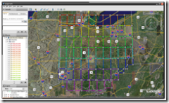
The picture above shows the gridlines and the picture below shows my found caches so far. I’ve actually found quite a few other pages but unfortunately they were before the cache was placed so they don’t count.

 Screenshot - 7_21_2007 , 5_32_55 PM

So far I’ve found pages 45-48,55-59,65 and 67-69

Meanwhile TeamJNLe4 completed all the pages yesterday and now just has to go for the final cache – congrats Jonathan!
New Mapping Software to geotag pictures

WWMX is the current software that I use to geotag my photo’s and I’m always on the lookout for some better software that will do the trick. Today I came across locr which seems really nice. The interface is cleaner and looks much better and also integrates with Google Earth and if you use locr then it also integrates with that website – It’s actually their bulk uploader tool.
However if you have a garmin gps you may find that loading in the waypoints does not work correctly so here are the complete steps for encoding your photos.

(more…)

New caching map tool

I discovered myGME this evening whilst doing some gsak work/experimentation. This gsak macro allows you to get a google map of all the caches in your currently defined filter set with a radius circle predefined to show you the caches within that area. If you want to move the area, you select the red marker icons and move them to the center of the circle and the distance away from the center. It works great. Takes a while to load if you have a lot of caches mind.
The graphic below shows the initial output for the geocaches near Hocking Hills.

myGME exports for Hocking Hills

More Caching maps

I’ve fiddled around with my google maps and now have the following two maps (that will be added to the sidebar). Firstly I have my UK finds and also my US finds, centred around Ohio. Both of these maps actually use the same set of data, the zoom and centre location is just set to show the UK and Ohio respectively. As the locationless caches distort the location of the caches that have been found I have also amended the data to not show locationless caches anymore.
Note that each map will open in a new window and you will need a screen resolution capable of showing 1000*800 characters. You will have to wait a few seconds after the screen has loaded for google to display the results.

Caching update

I won a Legend C with North america maps on ebay last night which is great – the autorouting should come in very handy for work too – and if the route just so happens to go past a cache – well “I am only following directions gov” 😉
On a slightly similar note, the weekly notification of caches arrived today (the uk cache notification!) but it had the interesting news that you can now get a query of caches along a route. If this works, it’s going to be great news for geocaching. Firstly there will be great rejoicing from the caching community and secondly this seriously reduces the need to horde cache information in gsak. Now I can get live cache data from a route online rather than having to download all of ohio into gsak, export all the caches as streetmaps pushpins, import them into streets and trips, create the route and then show caches within .2 miles.
I

Cache planning along a route in Autoroute

If you export your gsak caches into Streets & Trips/Autoroute, create a route and then use the Show or Hide places option you can get a list of caches along your trip. I’ve made a rough tutorial online

More GIS Links.

See the Dublin GIS links

Delaware county maps

DALIS-View Map Server contains information on land within Delaware county, great for seeing which land is public.
The Franklin county (dublin) version is here