Absocachinlutely! Rotating Header Image

gpx

Cacheberry for caching with the blackberry.

Currently I use a 8 or 9 year old Dell Axim for my paperless caching which has served me really well but it’s yet another device that I need to keep charged and carry around with me whilst geocaching. I’m about to go caching for the day today starting with the Pi day Party and then hitting about another 10 or so caches with Team JNle4 – yes, I have dragged him out of retirement too!

Anyway, I wondered if there was a geocaching application for the blackberry (work phone) and discovered Cacheberry which looks like it has an offline database, the ability to export field notes via email and also integration with google and blackberry maps.  So today I’ll be using this app and I’ll let you know how I got on.

Ohio Delorme Challenge

The Ohio Delorme geocache requires a visit to each cache in the Delorme atlas for Ohio but only visits after the cache was placed will count towards the cache find. Once a cache has been found on each page you then get the co-ordinates for the final cache hidden somewhere in Ohio.

With the aid of a KML file, the recent finds pocket query, GSAK and Google earth it is quite easy to work out which pages you need to do.

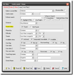
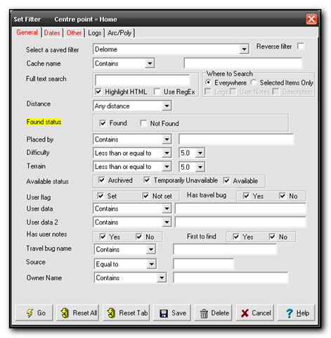
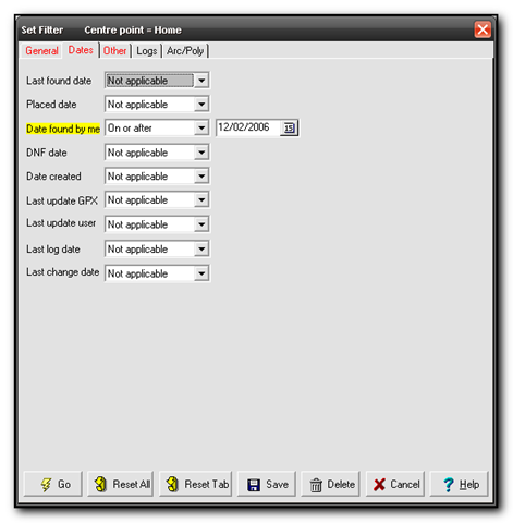
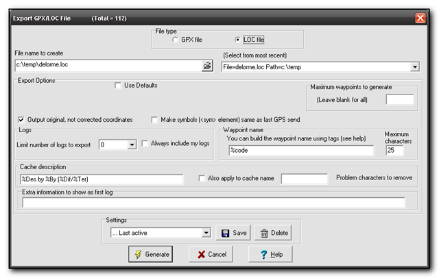
First download the Ohio Delorme KML file from the main cache page, GCZ554. Next download Google Earth (if you don’t already have it already. Finally  you want a .loc file of all your finds since the 2nd of December 2006 when the cache was placed.  The easiest way to do this is to download your latest finds into GSAK, then using the filters set State=Ohio, Found=Yes, Date=On or After 12/2/2006.  I saved the filter as Delorme so I can run this whenever I need to check my status.

Screenshot - 7_21_2007 , 5_31_23 PM Screenshot - 7_21_2007 , 5_31_12 PM Screenshot - 7_21_2007 , 5_31_16 PMScreenshot - 7_21_2007 , 5_31_47 PM   

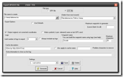
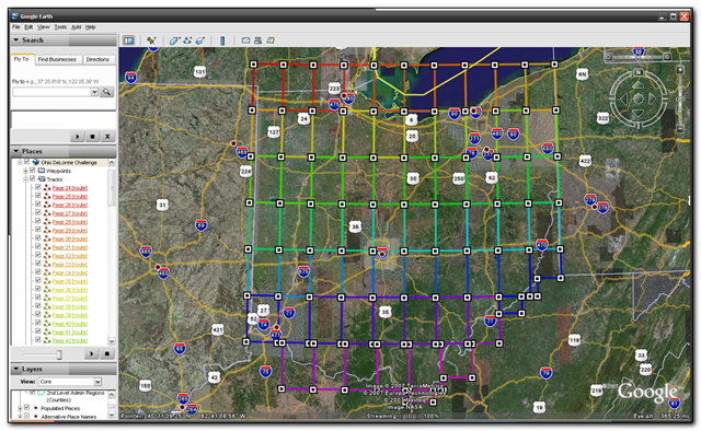
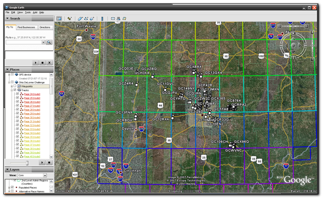
In Google earth open the KML file and then open the loc file  to see the caches appear in gridlines for each page. You may want to turn off extra options and layers such as road names, community uploaded content etc. This will give you a cleaner picture. Screenshot - 7_21_2007 , 5_32_03 PM

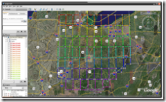
The picture above shows the gridlines and the picture below shows my found caches so far. I’ve actually found quite a few other pages but unfortunately they were before the cache was placed so they don’t count.

 Screenshot - 7_21_2007 , 5_32_55 PM

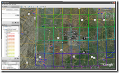
So far I’ve found pages 45-48,55-59,65 and 67-69

Meanwhile TeamJNLe4 completed all the pages yesterday and now just has to go for the final cache – congrats Jonathan!

New Mapping Software to geotag pictures

WWMX is the current software that I use to geotag my photo’s and I’m always on the lookout for some better software that will do the trick. Today I came across locr which seems really nice. The interface is cleaner and looks much better and also integrates with Google Earth and if you use locr then it also integrates with that website – It’s actually their bulk uploader tool.
However if you have a garmin gps you may find that loading in the waypoints does not work correctly so here are the complete steps for encoding your photos.

(more…)

GSAK 7 beta and stats

I ran a test installation of gsak 7 on my pc this week. The main reason for this was to install the statistics macro to generate the stats for my geocaching finds. There were a few prerequisites below – links point to the download page rather than the actual file to ensure new updates get downloaded.
First download the cutting edge, most feature packed aka beta version of Gsak 7.
Install the latest patch to bring you up to 7.1 build 64
Finally download the
FindstatGenv3 and whilst you are at it, I would highly recommend the Google Maps export macro too that produces a very cool google maps interfaces to caches.
Once you have downloaded and run the Stats macro, I recommend you download your “My finds” pocket query from Geocaching.com and save the results into a temporary GSAK database. This means the macro has less work to do as it only has to look through one log – yours. Even if you don’t do this the results are outstanding. The stats generation used to take 4 minutes to run in version2 of the macro – it now takes 20 seconds! The output can be seen at my Geocaching.com profile (although this is using the old version stats -I’ve not uploaded the new ones yet)

Caching update

I won a Legend C with North america maps on ebay last night which is great – the autorouting should come in very handy for work too – and if the route just so happens to go past a cache – well “I am only following directions gov” 😉
On a slightly similar note, the weekly notification of caches arrived today (the uk cache notification!) but it had the interesting news that you can now get a query of caches along a route. If this works, it’s going to be great news for geocaching. Firstly there will be great rejoicing from the caching community and secondly this seriously reduces the need to horde cache information in gsak. Now I can get live cache data from a route online rather than having to download all of ohio into gsak, export all the caches as streetmaps pushpins, import them into streets and trips, create the route and then show caches within .2 miles.
I

Google maps of found caches

With a bit of help from the gpsbabel mailing list, I’ve now been able to work out how to use the google maps api and the main page of this blog now shows all the caches that I have done around my home. As I find more and more caches then I’ll have to start the page zoomed out a bit more 🙂

Keyhole and caching.

Wow – by using the google keyhole software and gsak it is possible to extract data from gsak and create a kml file to import and see a satellite overview of all the caches.
You just need to save the custom export field as
“C:\Program Files\GSAK\GPSBabel.exe” -i gpx -f “c:\program files\gsak\temp\babel.gpx” -o kml -F c:\temp\25.kml