
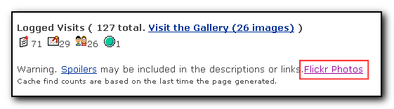
I have updated my Geocaching.com to Flickr greasemonkey script to work with the new geocache id’s. To install go to userscripts with a greasemonkey enabled browser to show links to Flickr from the Geocaching website as per the screenshot below.
For more technical information see my blog postings with the tag geocache2flickr
For those of you who don’t have greasemonkey installed yet, this allows you to download scripts that tweak the layout of normal websites to do various things such as add extra links, remove adverts etc. Greasemonkey can be downloaded from Mozilla addon site
Software
My Flickr and Geocaching greasemonkey script updated.
Cacheberry review
Yesterday Team JNLe4 and I went on a cache run to the south east of Columbus. The plan was to do about 30 caches but we managed 20. This is still the highest number of caches I’ve done in a day so I was pretty pleased.
This was also my first time using the registered version of Cacheberry and it worked really well. I’ve purchased a 4gb SD card for the Blackberry that I used to store the data on which also made it easier to transfer the gpx data from gsak to the blackberry.
The ability to quickly search for a cache,open the logs and hints really helps when out in the field and the option to save cache logs whilst out in the field and email the log file for “one click logging” is very useful.
As we did 20 caches with several travel-bug pickups I was actually saving the travel-bug information in the Blackberry note feature – but that was because I wasn’t sure how the field-note logging works. However, now that I’ve logged when I was back home I now know that I didn’t really need to do this.
It’s better to write the travel bug information into the field note in cacheberry and then as you log the cache itself by clicking on the saved log within the website you can delete the travel-bug information.
What would be nice would be a separate function to pick up the pre-existing travel bug information. Currently cacheberry knows that there is a tb in the cache but there is no interface to say that it’s been found or discovered. If you’ve used gpxsonar in the past you will be used to this function.
The other thing I’d like would be to have the time that the cache was found added to the online log function, I like to know how long it took me to go between each cache but once the caches are logged online this information is not available anymore (unless I go back to the cacheberry application).
I didn’t use the new compass facility (as I was using my gps) apart from one test cache find. For this cache I had both the gps and the blackberry running a search for the nearest cache. The Blackberry normally had the distance to the cache about 5-6′ shorter than the gps, but when it came to ground-zero, both the gps and cacheberry had the same information. I was very impressed at how quickly cacheberry updated itself with the position and it wouldn’t certainly make a good emergency gps if the main gps battery dies or if looking for that ftf without a gps available. I’m not sure how much using the gps affects the battery but I suspect it does make the battery life shorter.
Overall, this app is well worth the $15 registration fee for those blackberry owning geocachers
Cacheberry for caching with the blackberry.
Currently I use a 8 or 9 year old Dell Axim for my paperless caching which has served me really well but it’s yet another device that I need to keep charged and carry around with me whilst geocaching. I’m about to go caching for the day today starting with the Pi day Party and then hitting about another 10 or so caches with Team JNle4 – yes, I have dragged him out of retirement too!
Anyway, I wondered if there was a geocaching application for the blackberry (work phone) and discovered Cacheberry which looks like it has an offline database, the ability to export field notes via email and also integration with google and blackberry maps. So today I’ll be using this app and I’ll let you know how I got on.
Ohio Delorme Challenge
The Ohio Delorme geocache requires a visit to each cache in the Delorme atlas for Ohio but only visits after the cache was placed will count towards the cache find. Once a cache has been found on each page you then get the co-ordinates for the final cache hidden somewhere in Ohio.
With the aid of a KML file, the recent finds pocket query, GSAK and Google earth it is quite easy to work out which pages you need to do.
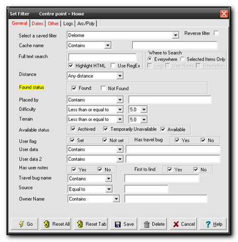
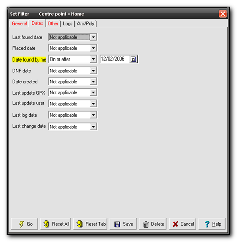
First download the Ohio Delorme KML file from the main cache page, GCZ554. Next download Google Earth (if you don’t already have it already. Finally you want a .loc file of all your finds since the 2nd of December 2006 when the cache was placed. The easiest way to do this is to download your latest finds into GSAK, then using the filters set State=Ohio, Found=Yes, Date=On or After 12/2/2006. I saved the filter as Delorme so I can run this whenever I need to check my status.
In Google earth open the KML file and then open the loc file to see the caches appear in gridlines for each page. You may want to turn off extra options and layers such as road names, community uploaded content etc. This will give you a cleaner picture. 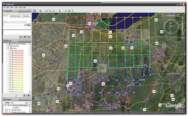
The picture above shows the gridlines and the picture below shows my found caches so far. I’ve actually found quite a few other pages but unfortunately they were before the cache was placed so they don’t count.
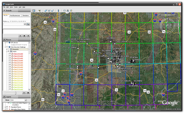
So far I’ve found pages 45-48,55-59,65 and 67-69
Meanwhile TeamJNLe4 completed all the pages yesterday and now just has to go for the final cache – congrats Jonathan!
New Mapping Software to geotag pictures
WWMX is the current software that I use to geotag my photo’s and I’m always on the lookout for some better software that will do the trick. Today I came across locr which seems really nice. The interface is cleaner and looks much better and also integrates with Google Earth and if you use locr then it also integrates with that website – It’s actually their bulk uploader tool.
However if you have a garmin gps you may find that loading in the waypoints does not work correctly so here are the complete steps for encoding your photos.
Cache planning along a route in Autoroute
If you export your gsak caches into Streets & Trips/Autoroute, create a route and then use the Show or Hide places option you can get a list of caches along your trip. I’ve made a rough tutorial online